The Pantheon Rome: Hotels, Sites, MapsThe Pantheon and Navona areas are the heart of the banking and political arena in Rome Italy, but don't hold that against the Pantheon area. This is the way it's been for the last two millennia and the area has still managed to retain its charm with undeniable ease! Quick jump to: • What to see • Getting around • Activities
The Pantheon area is very central to most Rome tourist attractions, and right on the doorstep of the triangle of my favorite Rome areas - Piazza Navona, Campo de Fiori and Trastevere. The only drawback, however, is its distance from the Rome Metro, but we'll discuss how you can easily get around that a little further down the page. Street Map of the Pantheon Area
Recommended Hotels near the Pantheon - Highest rated hotels by Guest Reviews
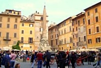
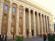
Also to be considered: Hotel Ponte Sisto What to see in the Pantheon area? Wandering through the Pantheon area you don't realize how close you are to so many of Rome's finest historical treasures. Approaching the Roman Pantheon from its rear you might not even look twice at its plain circular brick facade, not even a hint is given as to the spectacle that awaits within. It's only once you approach the front portico and its massive granite columns that the goose bumps set in...  Not 100m from Piazza della Rotonda in Piazza di Pietra you find the remains of the Temple of Hadrian. Originally built to honor the Emperor Hadrian and his son, the most visible remains are the front facade of 11 marble columns. The building is now home to the Rome stock exchange. In Piazza della Minerva, just behind Piazza della Rotonda, you find the Obelisk of Santa Maria sopra Minerva in front of the Santa Maria sopra Minerva church. It is believed that the church was built on top (sopra) of the ruins of the Temple of Minerva. It was built in the 13th Century and in the Gothic architectural style. It is richly decorated with a treasure of art representing some of the greatest periods and styles of Italian history. The obelisk of Santa Maria sopra Minerva, an elephant with an obelisk on its back, was originally intended as a decoration for Palazzo Barberini. It's a Bernini design (Bernini didn't lack an imagination or sense of humor) but the Friars from Santa Maria sopra Minerva liked it anyway. The elephant, according to Christianity, is the symbol of steadfastness, intelligence and piety. Piazza Colonna contains the Column of Marcus Aurelius, built in AD 180 to celebrate the Emperor's many victories over the barbarians. Getting to and from the Pantheon area.(Refer to the street map of the Pantheon area above.) Rome Metro: The closest Rome Metro station will be the Piazza Barberini stop on Metro Line A. It's about 1 kilometer (1600 yards) or a 15/20 minute walk from the Pantheon. Another option is the Metro stop at Cavour (Line B), which is marginally further. From Barberini you can either head across the Tevere towards the Vatican City or in the other direction towards Termini Station. Termini is the central station (metro, train, bus and tour bus) and where you can also change Metro lines. Rome buses: The main bus stop is on Via del Plebiscito (runs from Piazza Venezia to the Vatican) in front of Largo di Torre Argentina.
For more about the buses in Rome see my dedicated page Rome buses and Rome public transport. Rome taxi: There is a taxi stop at Piazza di San Pantaleo on Via Vittorio Emanuele - refer to the Pantheon area map above. It's about 100m after Largo di Torre Argentina on the right (in the direction of the Vatican). Rome tourist buses: There are many tourist buses in the Pantheon area:
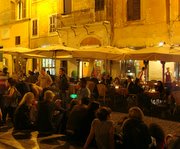
Note: If you have not heard about it already on my site then the ATAC public transportation in Rome site has a great tool to calculate the quickest route from point A to point B anywhere in Rome (using Rome public transport). When you arrive at the website click on the English language option to the right. Fill in your departure address and arrival address. For more information visit public transportation in Rome Italy and its related pages:Pantheon restaurants at dusk, Piazza della Rotonda, Rome Italy.
 Restaurants and nightlife in the Pantheon area. Most Rome nightlife happens around the immediate area of the Roman Pantheon and the Piazza della Rotonda. For those keen on letting their hair down then the Trinity College, in Via del Collegio Romano, is an Irish themed pub and a big hit with Italians. Alternatively you can stroll across to nearby Piazza Navona and Piazza di Campo de Fiori for a wider selection. For more advice about eating out in Rome visit my Rome restaurants page and also the Rome restaurant guide page for advice and tips from visitors to this site. Finished with the Pantheon area? Click on an area of the map below to visit another area. Central Rome Italy Map: Click on an area to go to its dedicated page. Return to the Rome areas summary: Rome Italy map
|
The Pantheon area locator

Central Rome areas dedicated pages: • Aventine hill • Campo de Fiori • Esquiline • Piazza del Popolo • Piazza Navona • Quirinal • San Giovanni in Laterano • Spanish Steps/Spagna • Trastevere • Trevi Fountain/Fontana • Vatican • Via Veneto 1. View All the Central Rome areas together: Street Maps Rome Italy 2. Maps Galore, find any Street Map of Rome Italy 3. Return to the Rome central area summary page: Rome Italy Map
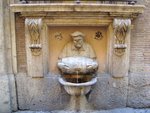
The Facchino drinking fountain, Via Lata, The Pantheon area. Fontanella del Facchino
|
|||||


